Today was another long day of driving to see the
sites. We headed out of Lijiang through some great valleys.


Our first stop was the First Bend of the Yangtze River. Through much of China the Salween River, the Mekong and the Yangtze run south and parallel to each other from Tibet. At the First Bend of the Yangtze River the river does an almost complete reversal of its course and runs parallel to itself for about 20 kilometers before heading north and east to Shanghai (the other two keep heading south through Southeast Asia). It was a pretty impressive sight and the mountains around the area are lovely.


Our first stop was the First Bend of the Yangtze River. Through much of China the Salween River, the Mekong and the Yangtze run south and parallel to each other from Tibet. At the First Bend of the Yangtze River the river does an almost complete reversal of its course and runs parallel to itself for about 20 kilometers before heading north and east to Shanghai (the other two keep heading south through Southeast Asia). It was a pretty impressive sight and the mountains around the area are lovely.


The village at the bend claims that they are guardians of
the river and caused it to change course and allow all of the water to remain
in China.
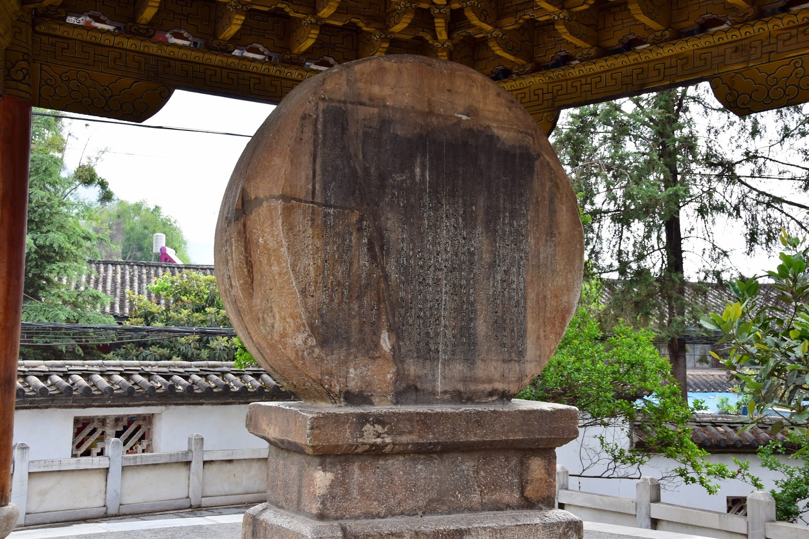
The village at the bend of the river is called Stone Drum Town as it is the site of a “Stone Drum”, a large
round flat stone mounted on its side and carved with Chinese characters. While it looks like a drum it cannot be
played.


The village is also the site of the Tiehong Bridge, a rather non-descript iron chain and wooden plank bridge that was instrumental bridge in the Long March, lead by Mao Zedong (1934 –
1935).
Workers were rebuilding some stone stairs. This lady was carrying buckets of concrete up to them for use in building the stairs. Tough job. Tough lady.

As usual, the drive to our next destination was through more beautiful mountains and farmland.


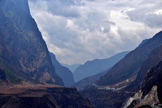
From there we headed to the Tiger Leaping Gorge, the third deepest gorge in the world after the Grand Canyon in the US and a gorge in Tibet.
We assume the yaks are here because we are in an area influenced by Tibet (and they are big on yaks there). The meaning behind the Tiger is pretty obvious.


Much of the drive towards the gorge was along the banks of the Yangtze River. There were a lot of sand and gravel bars. In places we saw heavy equipment in the river mining the gravel and sand.

The first stop in the gorge was where the tiger (being chased by hunters) used a large rock in the river as a stepping (leaping) stone to get to the other side of the river and escape.
The drive was really
spectacular with the greatest depth from the river to the top of the cliffs being 6,600 feet (2,000 meters). And from the surrounding mountain peaks being
3,900 meters (12,795 feet – over 2 miles).


The two mountain ranges on either side of the river are very close together - the gorge's narowest point is 20 meters. The main part of the gorge is about 15 kilometers long (9.3 miles).


 |
| Stone Drum |
 |
| First Bend in the Yangtze River, in the distance |
 |
| From Stone Drum Town |


 |
| Wheat and Potato fields |
 |
| Museum about the Long March |
 |
| Tiehong Bridge |
Workers were rebuilding some stone stairs. This lady was carrying buckets of concrete up to them for use in building the stairs. Tough job. Tough lady.

As usual, the drive to our next destination was through more beautiful mountains and farmland.


From there we headed to the Tiger Leaping Gorge, the third deepest gorge in the world after the Grand Canyon in the US and a gorge in Tibet.
We assume the yaks are here because we are in an area influenced by Tibet (and they are big on yaks there). The meaning behind the Tiger is pretty obvious.


Much of the drive towards the gorge was along the banks of the Yangtze River. There were a lot of sand and gravel bars. In places we saw heavy equipment in the river mining the gravel and sand.

The first stop in the gorge was where the tiger (being chased by hunters) used a large rock in the river as a stepping (leaping) stone to get to the other side of the river and escape.
 |
| The rock used by the tiger to escape the hunters. |
 |
| The Yangtze River is very low (end of dry season). The high water mark can be seen on the gorge walls across the river. |


The two mountain ranges on either side of the river are very close together - the gorge's narowest point is 20 meters. The main part of the gorge is about 15 kilometers long (9.3 miles).


The area is currently at the end of the dry season but the Yangtze was still running at a very impressive rate.


We had lunch at a Tibetan-style restaurant above the gorge – Paul had a banana pancake, without syrup, but it was very good, much like the ones we had in Tibet and Mary had an egg "sandwich" made with tortillas.

The gorge opened out into a broad valley. The views back to the gorge were pretty awesome.


There were also the usual farm animals being moved down the road.


After leaving the gorge we headed off into the mountains and through more great valleys. Took a million pictures. The scenery is just spectacular.


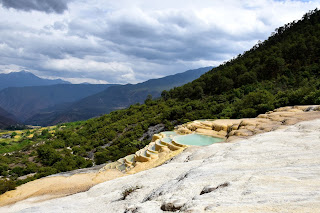
We stopped at the White Water Travertine Terrace, a series of small pools formed by Calcium Carbonate deposits. It was quite a hike up, mainly due to the altitude.


The fronts of the travertine pools were eerie and beautiful.


The pools were filled with turquoise water and they overlooked the valley. They were lovely but paled in comparison to Huang Long (Yellow Dragon) that we visited in our last visit to China in 2009.


We had lunch at a Tibetan-style restaurant above the gorge – Paul had a banana pancake, without syrup, but it was very good, much like the ones we had in Tibet and Mary had an egg "sandwich" made with tortillas.

 |
| Egg "Sandwich" |


There were also the usual farm animals being moved down the road.


After leaving the gorge we headed off into the mountains and through more great valleys. Took a million pictures. The scenery is just spectacular.


We stopped at the White Water Travertine Terrace, a series of small pools formed by Calcium Carbonate deposits. It was quite a hike up, mainly due to the altitude.


The fronts of the travertine pools were eerie and beautiful.


The pools were filled with turquoise water and they overlooked the valley. They were lovely but paled in comparison to Huang Long (Yellow Dragon) that we visited in our last visit to China in 2009.


Behind the pools that stair-stepped down the hillside were some shallow reflecting pools with great views of the valley beyond the the mountains behind.


From there we headed off through more mountains to Shangri-La
(original Chinese name was Zhongdian but officials decided to rename it – good for
tourism). It was a long drive through
valleys and along mountain sides and the views were spectacular if a bit hazy.


The most interesting parts were the pink mountain sides. The wild rhododendrons are in bloom and in some areas are veritable forests of very large rhododendron bushes, some the size of small trees. The concentration of rhododendrons was such that they turned the hillsides pink.


The most interesting parts were the pink mountain sides. The wild rhododendrons are in bloom and in some areas are veritable forests of very large rhododendron bushes, some the size of small trees. The concentration of rhododendrons was such that they turned the hillsides pink.


We saw the usual bucolic farm country and animals moving around from field to field.


We are at 10,367 feet (3160 meters) above sea level here in Shangri-La. And we are diligently taking our Chinese herbal medicine to combat altitude sickness. We’ll see how it works.


We are at 10,367 feet (3160 meters) above sea level here in Shangri-La. And we are diligently taking our Chinese herbal medicine to combat altitude sickness. We’ll see how it works.
Our hotel is built in the Tibetan style and has a lovely
courtyard overlooking a small lake. We
are on the fourth floor with skinny Tibetan style stairs and no elevator. At this altitude climbing the stairs is
exhausting, and we have to pause halfway up.


 Previous
 Next
Next
No comments:
Post a Comment